Showing posts with label Hiking Lemhi Mountains. Show all posts

Saturday, September 20, 2014

Climbing Nicholson Peak From Fowler Springs, Lemhi Range, Idaho

One of the problems hikers and climbers face in the Lemhis are access roads. There are very few marked roads which makes route finding challenging. It is frustrating seeing your destination and crisscrossing the desert in every direction but the right one. Initially I followed the advice in Tom Lopez's book to access Fowler Springs from the mouth of Badger Creek Canyon. The topo map actually shows a road in this area leaving the canyon and heading for Fowler Springs. I thought it should be pretty straightforward. Driving into the canyon, I kept my eyes peeled for any semblance of a road leading south and crossing Badger Creek. Once in the canyon, I concluded that any access road from this point would be impossible, so I carefully retraced my path to no avail. I saw some hunters at the mouth of the canyon and asked them if they were aware of any access across the creek and south. They knew of no such route. Next, I drove back to the highway and headed south. I turned off every side road I could find. Two looked promising but were eventually blocked by barbed wire fence; probably put there by landowners who were tired of closing gates left open by lazy drivers. Next, I found another road far to the south that, on the map, pointed to Fowler Springs. Following this road for some distance looked very promising. The route was heading right to the destination point of the springs on the GPS! Unfortunately darkness fell fast and the faint road in the desert was impossible to follow. 

I pulled over and bedded down for the night. In the morning, the road I was following was indeed faint, but I could see a definite road leading over a hill in the distance that looked like this was the ticket. Driving toward this distant road, I found my self with no road whatsoever and looking for passable routes to the hilltop location…off-roading in a Forester. Finally, I met up with the distant road and climbed the steep hill with the telltale smell of a burning clutch. My little car has taken quite a few beatings, yet keeps on going. I just hope I don't burn out a clutch in the middle of nowhere. Once again, I just knew this was the way. Reaching the top of the hill, a sturdy barbed wire fence blocked further passage. I had exhausted every possibility I could think of, and had only one last thought; if Tom Lopez wrote the springs were accessible from Badger Creek Canyon and if the map actually showed a road, I must have missed something. So, I headed for the highway and north again to Badger Creek. Once again I drove towards the mouth of the canyon scouring the brush for some way south. I struck out again. If there is a route there, I must be an idiot. Driving back to the highway, I had given up and even thought of walking the 6 or 7 miles through the desert to Fowler Springs. That thought quickly gave way to heading home and getting a Jamba Juice. I drove south towards Howe. Suddenly I saw a road that I had missed the night before and turned left into the desert. Eureka. This road was the one!

To help out the next traveler, I have recorded 3 GPS points that will provide information to make the journey to the springs a leisurely drive. The first is the turn off point from the highway. The second is a midway point. The third is the actual springs. Once at the final point, drive up the road just a bit to find a grassy area to park or camp.

N 44.02399 W 113.19722
N 44.05100 W 113.16235
N 44.06224 W 113.13763

climbing Nicholson Peak, idaho
Nicholson Peak, Lemhi Range, Idaho
climbing Nicholson Peak, idaho
Knife Edge Ridge Leading to Nicholson
I came along the top of the left tower and descended here between the two towers.
climbing Nicholson Peak, idaho
Diamond Peak, Lemhi Range, Idaho
climbing Nicholson Peak, idaho
Little Diamond Peak, Lemhi Range, Idaho
Ridge from Peak 10,965 to Little Diamond Peak
climbing Nicholson Peak, idaho
Lemhi Crest from Diamond Peak to Little Diamond Peak
Bell Mountain can be seen in the far distance on the left.
Saddle mountain can be seen in the far distance on the right.


Once at the springs, the hike is straightforward. You may have noticed some cliffs at the top of the ridge when approaching the springs. Hike up the spur toward these cliffs and bypass them on the left. After the cliffs, you will see the ridgeline point right to Nicholson Peak. Follow this ridge.


While hiking this ridge, it soon narrowed to a few feet wide and presented a series of small chimneys. I climbed up and down several with precarious foot and hand holds. I was reluctant to give up elevation by dropping off the top and skirting the narrow rocky spine below.  I am not ashamed to admit that I straddled the ridge a few times when it narrowed to the kind of point that I came off of the Chimney pictured above on the left. Finally, I had had enough and found a passage down to the talus at the bottom of the razor ridge. I decided to head southeast to the ridge that connected Nicholson and Peak 10,965 (Coined The Joker by Rick Baugher).  Baugher wrote that this ridge connected the two peaks and then, from 10,965, connected to Little Diamond. I just wanted to see this for myself.

The view was worth the detour. Little Diamond Peak sits at the south end of a large box canyon. The impressive crest from Little Diamond to Diamond Peak encloses the east side while Nicholson and peaks to the north rise on the west side.

After admiring the breathtaking view, I hiked back off the ridge, veering northwest towards Nicholson. I headed toward some cliffs that I knew must be skirted to ascend the summit. Once around these cliffs, it was simple climb to the summit. 

Coming down was one of the most pleasant descents I have ever had. A pleasurable hike. It was pretty easy scree skiing off the summit. I was reluctant to retrace the ascent route over the gnarly ridge, so I “skied” past it down into a gentle gully into the canyon to the south. I decided to follow this gully to the desert floor.  The gully was fantastic. Not too much brush. Not too many rocks and boulders. The rocks that were there acted much like stair steps. The hike passed by incredible rock cliffs and formations and most of the hike was in shade. My worry about the often-narrow passageway down cliffing-out never materialized.

Coming onto a thicket of Mahogany trees signaled the lower elevations of the descent. Once in these trees, I veered a bit to the north and could see the foothill that I needed to wind around to meet up with Fowler Springs. Coming around the bend on the hill, led me straight into my parked car. A perfect end to a satisfying hike.

Other Resources:

Tom Lopez Website:
Nicholson Peak

For more trip reports of other mountains visit idahoclimbing.weebly.com

Friday, August 15, 2014

Climbing Saddle Mountain, Lemhi Range, Idaho

Saddle Mountain Lemhi Range Idaho
Saddle Mountain, Lemhi Range, Idaho
Hiking Saddle Mountain is a "superior accomplishment" according to Tom Lopez, author of Idaho, a Climbing Guide: Climbs, Scrambles, and Hikes. There is just no easy way to the top.  In this post, I detail three possible routes that all lead to the summit.

Deer Canyon

My first attempt was to approach the peak from Deer Canyon on the east side of the mountain. To get there drive northwest on highway 28 towards Salmon. Turn off on a gravel road marked with a small sign identifying Bartel Canyon. Follow the road for some distance until you reach the foothills of Bartel Canyon and then turn left to access the southern canyons. The roads leading into the Lemhis are rough. (Good tires and four wheel drive give peace of mind. I travel in a Subaru Forester with Yokohama Geolander tires. I opted for solid all terrain tires after getting two flats high up in Skull Canyon earlier in the summer.)

I drove as far as my Subaru would take me and began traversing the northern slope toward the peak. My mistake was going to far into the canyon before trying to reach the north ridge. I found myself entangled in cliffs. I would skirt or climb a passable cliff only to be confronted by more daunting barriers. After dropping my water bottle over a cliff, I called it day and retreated back down the canyon. My experience taught me that an attempt on Saddle from Deer Canyon requires a quick ascent of the north ridge. After attaining the ridge, it should be a simple matter to follow it to the summit. See the below photo.

Saddle Mountain Lemhi Range Idaho
Saddle Mountain via Cedar Canyon and Deer Canyon
Cedar is on the left, Deer in on the right

Cedar Canyon

The next attempt, a month later, began in Cedar Canyon located south of Deer Canyon. As Ben and I approached the southeastern canyons, a storm was brewing over the Lemhis. We soon found ourselves in a downpour. I snapped a few photos just before we entered the storm. We parked at the entrance to Deer Canyon and rolled out our bags in the back of the Forester. Lightening in the mountains and heavy rain made the back of the car a cozy place to sleep.

Saddle Mountain Lemhi Range Idaho
Approach to Saddle Mountain From Highway 28
Lemhi Range
Looking North Towards the Birch Creek Valley
In the morning the sky was clear as we drove to Cedar Canyon. After driving into the canyon, we followed the road until it split and turned off on the left fork and drove to the end. Once at the end of the road, Ben and I begin hiking up the hill on the north. Traverse the slope until you make the ridge. Then follow it to the Lemhi Crest. Once the crest is gained, follow the ridge to the right . See the first photo for a suggested route out of the canyon. Below is a topo map of the basic route.

saddle mountain idaho
Saddle Mountain From Cedar Canyon
Saddle Mountain Cedar Canyon
Hiking Through Cedar Canyon
Not long into the hike, we were surrounded by heavy fog. Clouds clung to the eastern slopes of the Lemhis most of the time we hiked. We could not see to too far ahead and only knew we had to climb.

saddle mountain idaho
Hiking Through the Fog
Notice the bird lower center

Taking a Break

Bear Track?
We came out of the clouds only when we reached the crest. Turning right, we hiked the ridge toward the summit.

Saddle Mountain Lemhi Range Idaho
Lemhi Crest Looking Southwest into East Canyon
Saddle Mountain Lemhi Range Idaho
Hiking the Crest Toward Saddle Mountain
Saddle Mountain Lemhi Range Idaho
Saddle Mountain Comes into View
Saddle Mountain Lemhi Range Idaho
Saddle Mountain, Lemhi Range, Idaho
Saddle Mountain has two summits. the eastern peak on the right is the highest point This peak has a bona fide cairn, register, and large wood cross.  From some vantages the left peak appears taller. I just think this has to do with perspective.

Saddle Mountain Lemhi Range Idaho
On Top of Saddle Mountain
Saddle Mountain Lemhi Range Idaho
On Top of Saddle Mountain
Saddle Mountain Lemhi Range Idaho
Looking South From Saddle Mountain Summit
Looking North From Saddle Mountain Summit
Tyler Peak is in the Distance
Looking East into Deer Canyon
Saddle Mountain Lemhi Range Idaho
Looking South Down the Gully of Saddle Mountain
Saddle Mountain Lemhi Range Idaho
The Ridge to Saddle Mountain
Saddle Mountain Lemhi Range Idaho
Descending the Ridge of Saddle Mountain

Middle Canyon

The last route I explored was up Middle Canyon. To get to this canyon, drive past the toe of the Lemhis toward Howe. Nearing Howe, look north to see Three major canyons leading up to Saddle Mountain. The Canyon on the west is Black Canyon. The one on the east is East Canyon and of course the middle one is Middle Canyon.  A good map will show several dirt roads crisscrossing the desert. Find the road that eventually leads to Middle Canyon. The Canyon is about 2 to 3 miles long with it's own unique climate niche.  Walking in from the hot desert you find a place of lush firs, ferns, and wild raspberries.  When I walked out of the canyon around 5:00 pm, it was like walking out of an air conditioned room into the desert heat.  There is a decent trail leading into the canyon that is more difficult to follow the deeper you go.  Incedible rock formations flank the trail on both sides. Eventually, a sheer canyon wall several hundred feet high, on the left,  follows the canyon to the end.  The canyon is difficult to photograph.  It is often narrow and the walls are high.  I made a few photos of an interesting "shelter" on the west side of the canyon.  I know prehistoric people inhabited this area.  In fact, Jack Knife cave in East Canyon, the canyon just to the east, contains prehistoric art.  This shelter is made under a rock overhang in the canyon wall pictured below.

middle canyon lemhi range idaho


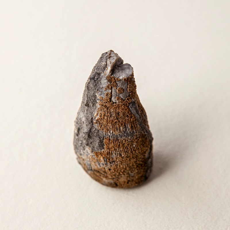
Both times I have hiked Middle Canyon, I found remains of deer carcasses.  The canyon seems like a perfect place for mountain lions.  I also found several pieces of horn coral in the limestone rocks in the talus found in the upper slopes of the canyon and on the steep slopes at the end of the canyon.  The cross section of horn coral below was found around 8,500 feet.  

Horn Coral, Middle Canyon, 8,500 Feet
At the end of the canyon a steep scramble leads to the ridge and summit of Saddle Mountain.  Be sure to veer left at the end of the canyon. It may seem counter intuitive to go left and not right towards the summit. I learned the hard way heading right leads to many insurmountable cliffs. by veering slightly to the left and then curving right near the top of ridge, you avoid the cliffs! Once on top, head northeast to come to the ridge leading to the summit. See below. Don't be intimidated by the view of the ridge. From this angle, the view is foreshortened and daunting. Skirt the ridge to the left and you will find a fairly easy climb to the top.

Saddle Mountain Lemhi Range Idaho
Detail Upper Ridge from the False Summit to Saddle Mountain Peak
Saddle Mountain Lemhi Range Idaho
Upper Ridge and Saddle Mountain Summit
From this angle, the peak on the left appears to be taller. I think this is a function of a wide angle lens. Objects closer to the camera appear larger while objects farther from the camera appear to recede into space.

Along the base of the ridge cliffs one can find a variety of fossils.  I will post photographs of the many fossils and rocks collected along the way in a few days. Look for the post titled Saddle Mountain Fossils and Rocks. I did, however, photograph several spectacular groupings of horn coral along the way and will end this post with these shots.

Saddle Mountain Horn Coral
Saddle Mountain Horn Coral 
Saddle Mountain Horn Coral
Saddle Mountain Horn Coral 
Saddle Mountain Horn Coral
Other Resources:
Tom Lopez Website: Saddle Mountain

For more trip reports of other mountains visit idahoclimbing.weebly.com

Thursday, August 07, 2014

Climbing Gilmore Peak and Meadow Lake

Ever since I photographed Meadow Lake last fall, I wanted to climb to the top of Gilmore Peak. The peak rises 1,400 vertical feet from the lake's surface and just looks cool. Ben and I spent the first evening in the Meadow Lake Campground. Ben fished a little and I photographed the lake and peak.


The next morning I was joined by Marvin Hansen on the hike to the top of Gilmore Peak. Marvin and his wife camped next to use in the campground and wanted to summit the peak. We followed a well maintained trail to the saddle north of the peak and completed several traverses to the top of the saddle.

The trail leads to the ridge on the left. We then followed the ridge to Gilmore Peak. This view is from the top of Gilmore looking south.
Meadow Lake Campground from the top of Gilmore Peak.
Marvin Hansen on top of Gilmore Peak.

Looking south from Gilmore Peak

A wider view of the above image.
The ridge to Gilmore Peak. Sawmill Canyon is behind while the Lost River Range is in the far distance. From left to right...Borah, Sacajewea Peak, Mount Idaho, Peak 11,967, White Cap Peak, Leatherman Peak, Bad Rock Peak,Mount Church, and Donaldson can be seen on the skyline in the left on the image.
The ridge leading to the summit of Gilmore. several couloirs are found between the peaks.
While descending, I noticed that the very first couloir was not as steep as it appeared from a distance, an illusion of foreshortening perspective and seeming compression of space. Instead of following the ridge back to the saddle and then traversing our way down, we went down the couloir. It was a simple descent. It took us about 3 hours to make the ascent from our camps and only took 50 minutes to arrive at camp using the couloir shortcut.

A final look at Gilmore Peak and Meadow Lake.


Other Resources:

Tom Lopez Website:
Gilmore Peak

For more trip reports of other mountains visit idahoclimbing.weebly.com