Wednesday, August 19, 2015

Climbing Sheep Mountain, Big Windy Peak, and Trail Peak, Lemhi Range, Idaho

August 16, 2015

The day after summiting The Riddler, John, Tom, and I were poised to make a threefer, three summits in one outing. We had driven to the old Hahn Townsite and found a place to camp near the mouth of Spring Mountain Canyon.  The turn off to Hahn is just south of the Gilmore summit on Highway 28. Tom and John talked about driving to almost 10,000 feet up Quartzite Canyon and then ascending by foot over a rolling ridge to top out on Sheep Mountain (10,865). Next we would jump back in Tom's Sequoia and drive to the base of Big Windy Peak (10,362). The plan was to ascend Big Windy and then hike over to the top of Trail Peak (10,553). I listened with slight amusement. It seems Tom and John had entered into a bit of good natured peak-bagging competition with a friend and were determined to not to come up short. A tip from a friend laid the strategy to claim three more summits in the morrow. John had already been up Big Windy Peak in the winter but hadn't snowshoed over to Trail Peak. This was his chance to bag Trail from Big Windy. I was along for the ride.

Driving up Quartzite canyon was tedious. The Sequoia rolled from rock to rock. Tom did his best to steer around large and sharp obstacles. I empathized with his chore of navigating the rough road and just bounced around the back seat until we reached our destination. The hike began with the rolling ridges to Sheep Mountain.

The path to Sheep Mountain lies ahead

Rolling hills to the summit of Sheep Mountain

Tom and John walking the ridge to Sheep Mountain

Noticeable rock glaciers in a distant canyon

Tom and John

Returning from Sheep Mountain far right

We then drove to the base of Big Windy Peak and began the ascent.

Heading up Big Windy Peak
Sheep Mountain in the distance from the second parking place
Tom and John walk by a mining test dig pit?
Tailings piled high on the horizon (near center) from a large dig
Big Windy Peak 
The summit of Big Windy Peak is unique in so much as it is a large plain. John discussed the possibility that it is a peneplain. The end result is a broad high point with the summit cairn looking like it is sitting in the middle of a field and not on a typical mountain peak.

Big Windy Summit Cairn
Just a cool incongruent object on Big Windy Peak
Now that's art
The summit of Trail Peak is in the distance on the left
On the summit of Big Windy, Tom decided to head back to the car. John and I took off to tag the summit of Trail Peak. We made good time and found a good trail up the side of the mountain.

Sheep Mountain from Big Windy Peak
Notice the haze all around. Smoke from wildfires sadly obscured the views
Looking southeast on Big Windy
For some reason this view reminded me of Machu Picchu
Mount Inspiration in the distance
John crossing the plain on the way to Trail Peak
Trail Peak from the plain of Big Windy Peak
The summit is the peak on the upper left
John Platt Photo
On the summit of Trail Peak
Bell Mountain in center distance
Mount Inspiration for future reference
Once back at the car I made a few images of old mining remnants around the area. I am including a few here just for interest sake.

Structure and tailings pile
Remnants of an old tram system
We did not return via Quartzite Canyon. Rather we descended on the main road right at the Base of Big Windy. Here's a photo of the road and Big Windy Peak.

Main Road in front of Big Windy
A final image of Trail Peak and the descending road
GPS tract to Big Windy Peak and then on to Trail Peak
On the way down, I set a GPS route to gather stats on the drive from the high point of the road to the highway. Here is the track and pertinent stats.


For further reference check out the following links:

John Platt, Splattski, Big Windy Ridge Report

Tom Lopez, Idaho A Climbing Guide, Big Windy Report

Tom Lopez, Idaho A Climbing Guide, Trail Peak Report 

Tom Lopez, Idaho A Climbing Guide, Sheep Mountain Report

For more trip reports of other mountains visit idahoclimbing.weebly.com

Climbing Peak 10,225 (Roundup Peak), Copper Basin, Idaho

07/08/2015

Roundup Peak, Copper Basin, Idaho
The mountain overlooks the annual cattle roundup held each fall in Copper Basin.
Roundup Peak, Copper Basin, Idaho

Copper basin is tucked between the Pioneer Mountains and the White Knob Mountains. It is best accessed from Trail creek Road connecting Ketchum with the Big Lost River Valley. About midway, the road to Copper Basin leaves the Trail Creek Road and follows the East Fork Big Lost River southeast eventually running along the east side of  the basin. You know the basin is near when the hulking mountain Big Black Dome comes into view in the west. The next road to the southwest follows Star Hope Creek to the popular Star Hope Campground at the southern tip of Copper Basin. This road also provides access points for many climbing opportunities in the Pioneer Mountains. See photos below.

View from the top of Roundup Peak
Big Black Dome on for right
Big Black Dome (right) and Pyramid Peak

Detail of the southern ridge
Altair, Standhope, The Fin
Not turning off on the Star Hope Creek Road eventually takes you to the access road for the eastern edge of the basin. You will see a guard station signaling this turn to the west. This road will take you to Lake Creek Canyon, Muldoon Canyon, and will eventually to the southern tip of the basin and Star Hope Creek Campground. Yes, both roads connect at the southern tip.

Our destination for the day was the Lake Creek Recreation Site at the head of Lake Creek Canyon. There is a small campground there with access to water. Also, the campground is at the head of good hiking and biking trail that heads up the canyon to several small lakes. The location is right up against the southwest slopes of Roundup Peak. A short walk into the canyon reveals the gnarly slopes of the backside of the mountains leading to Copper Basin Knob.

Southwest slopes from Roundup to Copper Basin Knob
Ben and I met Tom and his wife Laurie here at the campground and planned on climbing in the morning. The weather was not playing ball and we knew that we would have to adjust our plans accordingly. Afternoon thunderstorms would likely throw us some curves.

Once at the campground, I realized that I forgot to pack the stove when I began looking forward to the chicken mole that was thawing in the cooler. Damn. I was so excited when Laurie warmed up the mole, rice, and black beans on her stove and added wonderful warm tortillas to the spread. We all enjoyed a pretty mean dish of mole that night. Ben of course, wouldn't eat the mole, so Laurie spoiled him by making him tomato soup and a cheese sandwich. We broke out our fancy cream sodas and were living high that evening!

In the morning, we retraced the road around to the north and approached the peak from the gentle north slope running to the southeast. Eventually, making the ridge just to the side of the rocky face shown above. The hike was pleasant. Numerous wildflowers dotted the hillside.  Ben and I took the chance to appreciate their beauty several times during the ascent. I really enjoyed the hundreds of Sego Lilies on the mountain.


Tom Lopez Photo
Tom Lopez Photo
Tom Lopez Photo
Looking over Lake Creek Canyon
Tom wanted to get a picture of Ben doing a handstand out on this rock
Ben just wasn't accomodating
Tom Lopez Photo
Ben and I on the summit
Ben brought a bag of those red-hot Cheetos for a summit snack. Tom and I both gave him a hard time.

Tom and Ben on the summit
View of Lake Creek Canyon from Roundup Peak
Atlas Peak, just right of center, is the kind of mountain you want to climb because it is so beautiful
Alcon Peak is one in the distance
Once on the summit, our plan was then to traverse over to Copper Basin Knob. The clouds to the south didn't look promising. We decided to call it good on the top of Roundup Peak. The extra time that day gave Ben and I a chance to explore Copper Basin and make a few more photos of the area. See Below.

From the main road
From the main road
Driving in on the Star Hope Creek Road
Big Black Dome 
Glide Mountain over Star Hope Campground
Glide Mountain
The next day, on the way home, Ben and I decided to take the Burma Road from Copper Basin to the Big Lost River Valley. I have always been intrigued by this road on the map. Perhaps the lore of the WWII Burma road added to my intrigue. Anyway, here are a few images made on the Burma Road.


For more details of this trip, please check out Tom's report.

For more trip reports of other mountains visit idahoclimbing.weebly.com

Monday, August 17, 2015

Climbing The Riddler, Lemhi Range, Idaho

August 15, 2015

The Riddler on left

It was good to be going to the Lemhi Range once again. I tend to think of this range in a personal way  and to be back in the Lemhis would be a little like being back home. Unfortunately, or perhaps fortunately, this range is eclipsed by the proximity of the Tetons in the east and the Lost River, Pioneers, White Clouds, and Sawtooth Ranges in the west.

When people, from this side of the state, find out that I like to walk up mountains, their first question usually is, "Have you climbed the Grand?" Their are many implications to such a response, but in general I think such inquisitors are seeking to validate an individual as a climber as to whether or not one has summited the Grand Teton. I usually reply that I would like to climb the Grand if the opportunity arises and I feel I have developed the requisite skills to safely scale the mountain. However, I secretly harbor a personal response that I never vocalize: I am a bit proud to say that I have never been to the top of The Grand. My contrarian side rises with the constant barrage of, "Have you climbed the Grand." There are thousands of peaks offering a lifetime of adventure in Idaho alone! Many of them seldom climbed. Yes, I really do want to climb The Grand someday, but in the meantime I would just like someone to ask, "Have you climbed the Riddler?"

The vast, seldom trod spaces of the Lemhis offer solitude and a spirit of exploration that appeals to me. Exploring high mountain tops in the Lemhi Range is fulfilling precisely because they lack the pretension of other ranges. The Riddler just south of Diamond Peak is a classic Lemhi peak and promises what I like to call a Mini Adventure in one's own "backyard." The approach from the east is beautiful. The climb offers some challenges: the number of summits can be likely counted on two hands. It is a well rounded adventure. When such a trip is mixed with good company, all is right with the world for a few days.

I left Rexburg late Friday evening to meet Tom Lopez and John Platt at the small campsite/trailhead located at the end of Pass Creek Road. We had postponed the trip by one day because of weather. The decision turned out to be fortuitous. Driving out of Rexburg, the skies were dark and rain pelted the windshield. The weather band reported 60 mph winds at Sage Junction. I would pass through the junction within twenty minutes. I drove on into the storm, pretty sure it was on its way out of the area. Was able to make several images of the receding front on my way to the Pass Creek turnoff.

Saddle Mountain and Tyler Peak
Diamond Peak and The Beaverheads
My trusty white horse parked off Highway 28
The Beaverheads
Heart Mountain on the far right
Desert Sky
Big Southern Butte and the toe of the Lemhis on the right
To find the Pass Creek turnoff, turn northwest on highway 28 just west of Mudlake. As you approach Lone Pine, look for a sign indicating the Pass Creek turnoff. If you end up in Lone Pine, turn around and look carefully. It is not far from Lone Pine. The road is in excellent condition. I would not hesitate taking a car to the trailhead this time of year. In the spring, with runoff, there may be a few sections of the road where a car may not be the best idea.

Met Tom and John around 9:00 PM. Talked a bit and bedded down for the night. In the morning, had a light breakfast and began the hike around 6:00 AM.

Photo by John Platt
Soon after leaving the ATV trail
Big Boy in the distance
Navigating the approach was a bit tricky. Following the ATV trail we knew we needed to head up one of the side canyons leading to the mountain. It was tempting to turn up the first canyon. Turns out the second canyon was the ticket. We soon found ourselves in forested canyons that seemed to veer off in confusing directions. Looking at the map a few days before, I thought we might have some problems in such terrain and had planned a GPS route on my watch. The few times we consulted the planned line boosted our confidence we were headed in the right direction. It was nice to have the navigation aid.

Once above treeline, we encountered a series of talus slopes leading to the end of the canyon.

John on a talus ridge

The next slope

I just liked this composition


Tom cresting a ridge
John (lower left) making the next ridge

John seriously looking forward to the next slope of talus leading to the gate in the rock band

The Gate comes into view

Tom above The Gate

 Into the fun part
The daunting maze of The Riddler

At the very end of the canyon, we studied our very spotty resources to determine a way through what was above. John and Tom identified a series of gullies that would hopefully lead to the crest and then the summit. The climbing was class 3, but the terrible quality of the rock in the gullies raised my level of concern above normal class 3 climbing. To mitigate the possibility of hazardous rock fall, we took turns going up gullies and signaled the lower climber to proceed once we were out of the line of fall for that particular chute. I think I held the dubious record for knocking the most rocks down the mountain.

Out of a gully looking for the next line


Photo by John Platt
Taking a break. I liked my rest breaks!

Photo by John Platt
Tom showing how its done

Photo by Tom Lopez
A great view of a typical gully climb!
Photo by John Platt
Almost to the main ridge
Ridge to Big Boy in the distance
Photo by John Platt
Tom and myself on the main ridge
Diamond Peak behind us!
John and Tom on the summit
Diamond Peak from the summit of The Riddler
Looking east
We came up the drainage on the south
Looking south
Bunting Canyon 
Tom Lopez, myself, and John Platt
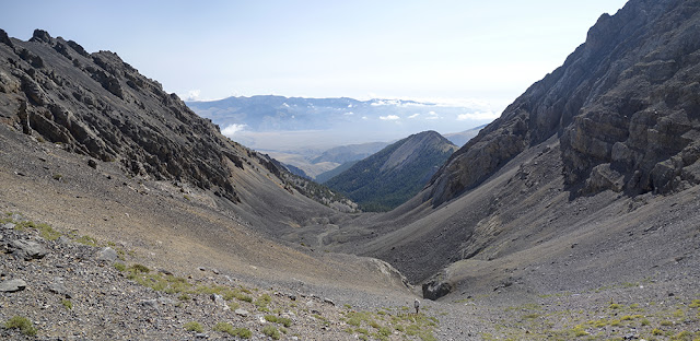
Looking down the drainage we ascended
Heading down
Photo by John Platt
I absolutely love seeing this animal
John remarked that there were a few more old goats on the mountain that day

Cool formations near the trailhead

Nearing the end of the trail

Sick formations
We took a short break at the campsite then packed up and drove to the old Hahn area to camp in anticipation for the next day. Made camp overlooking the valley. Enjoyed a hot meal, drank cold drinks, listened to great music, shot some holes in the breeze. Remarked more than once that life just doesn't get much better. Be sure to check out the trip reports of both John and Tom. See links below.

Photo by Tom Lopez

Photo by John Platt

John Platt Riddler Trip Report

Tom Lopez Riddler Trip Report 

For more trip reports of other mountains visit idahoclimbing.weebly.com