- March 12, 2016
- Team: James Helfrich, Meieli Allen, Brenda Cude, Myself
- Summit:
- Mount Church, Attempt
- Route: Drainage north of Jones Creek via Lone Cedar Creek Road
- YDS: Class 3
- Total Elevation Gain: approximately 5,500 ft.
- Total Miles: approximately 13 miles
 |
| Left: Brenda Cude approaching Donaldson Right: Me taking the photo of Brenda, James Helfrich photo |
The idea of a winter ascent of Mount Church has been rattling about in my thoughts ever since I saw a photo of someone making the snow covered summit. The climber and the peak could have been taken in some exotic range anywhere in the world. In my small sphere, it was the sum of mountaineering in the most romantic sense.
After last month's summit of Daisy Black during an attempt of Tyler Peak in the Lemhis, the Daisy Black group decided that a winter summit of Mount Church would be a respectable challenge. A date was set for March, and we anxiously looked forward to the climb.
The day came to depart for the mountain and the group dynamic changed. Jeremy opted out because of illness and James Allen decided to stay home with sick kids and send his wife Meieli. Along with Meieli came her friend, Brenda Cude from Ashton. Both Meieli and Brenda were upbeat and strong. Their effervescent personalities added to the demeanor of the team.
We drove over to the Lost River Range after work on Friday. Stopped at Pickles for dinner before continuing to Lone Cedar Creek Road and the trail head of the drainage north of Jones Creek. We were in our bags by 8:30 with a 4:00 A.M. wake up time. Despite plenty of time to sleep, I was extremely restless. Still awake at 12:30, I just gave up on the idea of sleep and decided there were worse things in life than climbing a mountain with no sleep. Freed from the pressure to sleep, I think I dozed off for a couple of hours before the 4:00 A.M. alarm.
The early morning sky looked promising. Patches of stars shined brightly through a broken cloud cover. We knew we would be rolling the dice with the weather and were encouraged by this good omen. We dressed, ate a quick breakfast, and were on the trail by 4:45. The route follows a drainage east into the mountains. There is a trail that avoids serious bushwhacking but the snow and darkness made it difficult to find. We often zigzagged up the stream bed through thickets and trees. There is no wrong way up, but when we did find the trail, the hike was much more enjoyable.
With morning light, we were greeted by the beauty of the narrow canyon. The snow was often deep and trail blazing was slow, but the solitude and views were rewarding.
 |
| Breaking trail up the drainage, James Helfrich photo |
 |
| Meieli breaking trail using the swimming technique, James Helfrich photo |
 |
| Coming out of the canyon, James Helfrich photo |
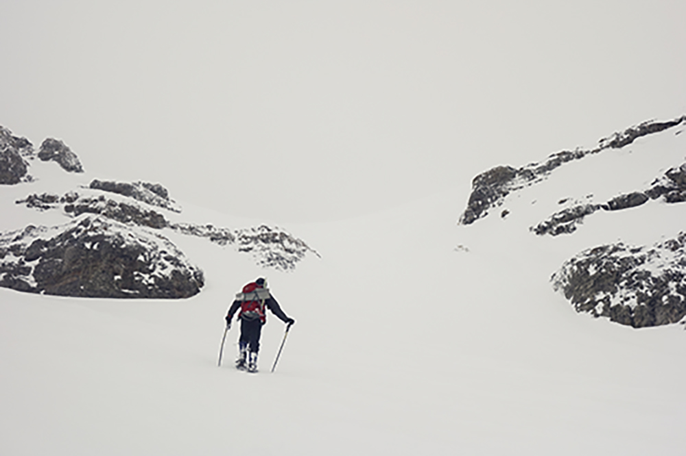
Once out of the canyon, we noticed the low cloud level ahead. Just the lower bands of rock on Church were visible. We knew that the route would take us to the south round the face of Church to the ridge between Church and Donaldson. Just how far to go and how high we should make our traverse was guess work as landmarks disappeared in the fog and occasional snow flurry.
 |
| Finding the route to the upper cirque below the head wall, James Helfrich photo |
James had been on this route several times before and had a good sense of where we were. His navigational skill proved to be extremely valuable. Once in a while more of the mountain would appear and we corrected our course accordingly. Soon we found the rocks of Donaldson and knew that the head wall was in our reach.
 |
| Heading to the upper cirque, James Helfrich photo |
Finally the entrance to the upper cirque lay ahead. We guessed that the entrance was marked by the rock on both sides. GPS later confirmed our hunch.
 |
| James Helfich entering the upper cirque |
The first crux of the climb, we knew, would be navigating the maze of cliffs up the head wall to the upper ridge. The second crux would be walking the exposed ridge to Church. The ridge would require several short climbs on rock and snow with great exposure. Now we were confronted with the real possibility of not even being able to plot a line up the wall due to the whiteout we found ourselves in.
 |
| Increasingly poor visibility, James Helfrich photo |
We plodded ahead with the remote chance the clouds would break. Despite the thick fog, other conditions were near perfect. The temperature was moderate and the wind was little to none. The snow was just right for snowshoes. At one point we decided to wait out the fog. we layered up and rested. We discussed the option of climbing the wall if visibility became better. Even if we could make the ridge, we concluded that this may not be prudent. There was the real possibility of being on the ridge and having the clouds roll back in. Trying to thread our way, down climbing, through the maze of cliffs on the wall without seeing would be tense to say the least. At a little over 11,000 ft, we decided to turn around.
 |
| Hustling back to the canyon, James Helfrich photo |
We jetted down the canyon and back to the car. Once on Highway 93 we had a good look at where we stopped just below the wall. We all felt strong and knew that had the timing and weather been better, the summit would have been a good possibility. We did revel in the chance to be out in the mountains as a group. It was a beautiful day and the experience of being in a white void was aesthetically unique. All in all a great time.
We stopped in Mackay for dinner at Mary Lou's. I ordered a rib-eye medium rare. The steak was a perfect meal after the outing.
 |
| Below the Head wall between Church and Donaldson |
1 comment:
These images are fantastic! Absolutely love the one with the three climbers in the snow with the peaks poking up on the right.
Post a Comment