 |
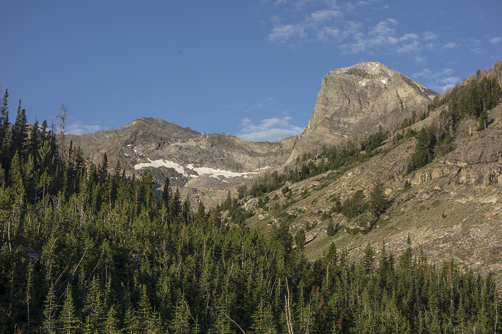
| Devil's Bedstead East from the Boulder Creek approach |
- July 30, 2016
- Team: Roldolfo Jodra and me
- Summit:
- Devil's Bedstead East
- Peak 10,942
- Route: Northeast Ridge
- YDS: Class 3
- Total Elevation Gain: 5,023 feet
- Total Miles: 9.06 miles
Driving south along Wildhorse Creek the smoke was so thick that I could just make out the mountains on each side to the road. I was to meet Roldolfo Jodra at the Wildhorse Campground that Friday and Climb Devil's Bedstead East the next day from the Boulder Creek Trailhead. I was not excited to climb in the smoke and was already making plans to retreat to the Lost River Range which was smoke free when I passed it an hour ago. One of the compelling reasons I climb mountains is summed up by Robert Adams, a noted photographer, who explains why photographers often leave the trodden path. "it's the view, stupid." The smokey Wildhorse Creek valley was not helping my motivation.
When I met up with Roldofo, I immediately began to steer our plans to climb in the Lost River Range, explaining it was smoke free. He was not swayed. I resolved that his commitment was important enough to climb the bedstead come smoke or high water. We settled down in a campsite and chatted for the rest of the evening. Roldofo enjoyed a civilized colorful pasta dish. I cordially declined to share in his fare, remembering that I had choked down a Taco Bell burrito 3 1/2 hours ago before leaving Rexburg. When he broke out a dish of sweet cantaloupe, I gave in and was all to happy to share in this part of his meal. It was delicious! We bedded down for the night with the forthcoming trek on our minds. I had wild dreams about wandering through forgotten creek-fed woods with bison, lions, and bears. Crazy.
The next morning we awoke around 5:00 A.M. I looked at the dark sky and could see stars. A good omen. We were at the trailhead at about 5:45 and immediately faced the crux of the day. If we were not entirely awake, we were jolted into alertness when wading through brisk Boulder Creek. I dreaded this early morning part of the journey.
The year before I had waded the creek in the early spring with high water to attempt a climb of Devil's Bedstead. I made it just about to the first lake when rain and lightening chased me off the rocks and back down the trail. The attempt had been a spur of the moment idea and I was wearing all cotton clothing. The clothing quickly became cold and heavy. Luckily I was wearing wool underwear. I stripped down to my skivvies and trudged through the mud and rain back to the trailhead. Under such conditions I thought I did not have to worry too much about anyone being shocked by an encounter with an ugly old guy running through the woods dressed only in his underwear. Anyway the wool did its job. I was wet but warm all the way back to the creek. This time the creek crossing didn't go well. The already high water was a torrent and took me for a rocky tumbling ride. Dragging myself to the other shore, I quickly made it to the car and heater. This July, the crossing was mild but chilly.
 |
| First good view of the mountain |
 |
| Roldofo on the trail |
The trail to Boulder Lake is in excellent shape and quickly rises through a series of switchbacks. Within an hour we were in the in the basin below peak 10,942. We decided to traverse Southwest along the east slopes of 10,942. Gaining elevation as we made our way in the general direction of the lake at the base of the saddle. We noted that there were several places where we could pass through the cliff bands that guard 10,942 and opted to take a scree filled gully to get above them to see what we could see.
 |
The mountains circling the southern end of the basin
I believe this is Abel Peak in the center |
 |
| Scree gully leading through the cliff bands |
I believe this gully was about the second to the last gully that penetrated the bands. We would have eventually come to the lake below the saddle had we not decided to abandon the traverse and head west and up. This choice, however, afforded us stellar views of the upper basin and an encounter with two local females.
 |
| Two curious locals |
 |
The lake right below the saddle between Devil's Bedstead East and Peak 10,942
as seen from the cliffs to the northeast |
 |
The best place to fiddle with a camera near a precipice is on your rear!
Photo by Roldolfo Jodra |
Next, we continued traversing to where we thought the saddle would be. It soon came into sight at about 10,300 feet.
 |
| The saddle comes into view |
The rest was straight forward. Make the north ridge and go up. To get there required careful hopping through a long series of boulders. We knew the north ridge led up a significant tower along the way. Not wishing to down climb the tower and lose elevation, we circumvented the obstacle by walking around it and up in a spiral-like path. This plan worked perfectly. we ended up back on the ridge at the exact point the other side of the tower intersected.
 |
| The edge of the saddle in foreground, the first bump, the tower, and the summit |
 |
| Now the tower |
 |
| The tower looks as daunting here as it did then |
 |
| Washington Lake from the north ridge |
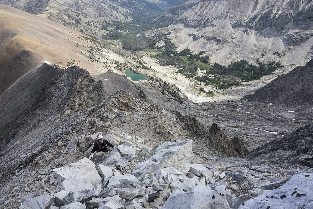
Then next part of the climb entailed hundreds of feet of steep class 3 climbing up blocky boulders. Not terribly difficult but some might find the steepness to be a bit unnerving.
 |
| The slope of the climb |
 |
| Rodolfo climbing another pitch |
Soon, we were on the short ridge leading to the summit.
 |
| Rodolfo walking the ridge to the summit |
 |
I actually have a summit photo thanks to Roldolfo
Note the ceremonial deer skull marking the top |
Spent about 45 minutes lounging on the top. I was eyeing peak 10,942 and making plans to collect it's summit on the way down. What really interested me was the possibility of a scree slide from its top to the trail some 1,700 feet below.
 |
10,942 beckons in the north
Borah can be seen on the horizon near the center |
The Pioneer crest with Old Hyndman, Salzburger Spitzl, and Goat Mountain dominated the view to the southwest while Lost River peaks could be seen in the east.
While taking in the sights, I noticed two more climbers coming up the north ridge and knew we would intersect paths on the way down. Sure enough we met. I recognized one as Matthew from the spring outing of the Idaho Summits group on Scorpion Mountain. Interestingly, we learned that they had camped right beside us the night before. This might not seem too coincidental except that the choices for camps sights stretches for miles. We exchanged some information and continued towards 10,942.
 |
| 10,942 just begs to be climbed |
Upon reaching the saddle, storm clouds had built up in the south and the wind was gusting as if to usher in a respectable storm. We agreed that at the first sign of thunder we would drop of the ridge and head for lower ground whether or not we made the summit, then continued hastily up the ridge.
We made the summit in no time! In fact within and hour we had summitted, scree skied, and made the basin floor about 1,700 feet below.
 |
| Roldolfo summiting 10,942 |
 |
On the summit of 10,942
Nice pirate hat thanks to the wind
photo by Roldolfo Jodra |
 |
| Looking back at the Devil's Bedstead |
 |
| Let the scree ski begin...more like scree slide |
 |
| Looking back up the gully I came out of before reaching the main trail |
Once on the main trail, it was smooth going back to the trailhead. Below you can find information about our route on Caltopo.


1 comment:
Thank you so much for your valuable trip report and the gpx!
Post a Comment