Pioneer Pilgrimage
 |
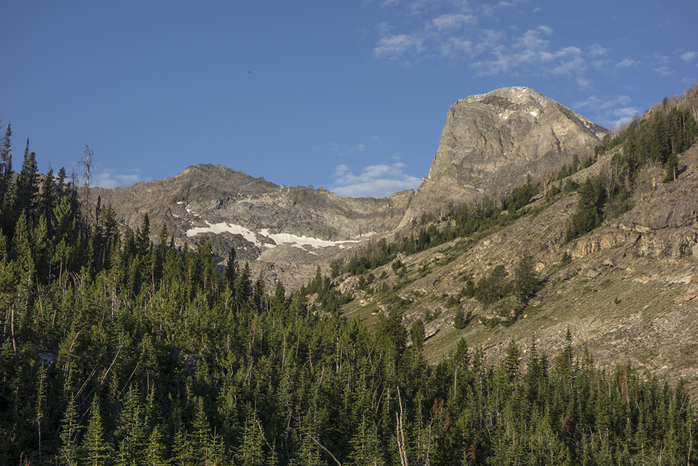
| Hyndman Peak (behind the ridge on left), Old Hyndman, and Cobb |
I began walking up mountains a little over a year ago. In the beginning I was going to spend my time in the Lemhi Range about an hours drive west of Rexburg. I planned on documenting the Lemhis in a way that few, if any, had done before. It wasn't long until distant peaks in other ranges worked their way into my imagination. I purchased
Idaho, a Climbing Guide: Climbs, Scrambles, and Hikes by Tom Lopez and read it like a novel. What began mainly as a photographic endeavor evolved into something that now has a quite different motivation. Yes, I still carry a camera (actually two) and a tripod. But, now I get out just to be active and in the mountains. Yes, I still try to position myself for interesting photos. But, now I am more apt to rely on serendipity; the journey has indeed become more important than being in the right place at the right time. Am I disappointed when I return from a trip without a satisfying image? Not as much as I used to be.
In Idaho, I learned there are nine peaks that are recorded at over 12,000 feet. They are referred to as The Twelvers. Among Idaho scramblers and climbers, this group of peaks becomes a coveted prize. Last May, I climbed Diamond Peak. In June, Ben and I climbed Borah and Leatherman. With three of The Twelvers climbed, the idea of summiting the remaining six was now bouncing around in my head. When I think too hard about this idea, I can't help but conclude that this is one absurd endeavor. to climb a group of mountains based on the fact that they are all over 12,000 feet is a bit silly. Even a bit more absurd was the goal I set to accomplish this task within the arbitrary time of one year. To my credit, I did not obsess over this goal. I climbed many peaks during the last year based upon the aesthetics of a certain mountain or the potential view from the top. Yet, the idea of closing The Twelvers loop was always near the surface of my thoughts.
With the arrival of this May, I lacked only one peak, Hyndman Peak in the Pioneers. Plans were made to close the loop on May 16h. Despite the fact that it had rained for a solid week and the forecast called for another week of rain, James Helfrich, James Allen, and myself traveled to the Hyndman Creek Trailhead the evening of the 15th. We awoke to a drizzle and clouds so low that we could not see any landmarks. After some confusion, we headed up the north fork of Hyndman Creek. The drizzle turned to rain. Soon James 2 was pretty soaked. The DWR coating on my Gore-tex jacket had worn off making it breathe like a plastic bag. Perspiration had me fairly soaked. James 1 was fairly dry! We slogged on. After a few miles we came to the end of the canyon and no trail. All we could see were slopes leading into the low clouds. Concluding we took the wrong trail, we turned around and headed down. Given the miserable conditions and the fact that we did not know where we were, we wisely decided to give up the summit and head to Ketchum to have breakfast at the Kneadery. I thoroughly enjoyed the Popeye Omelet.
Rain continued all the next week. The weekend of the 23rd brought more rain. Work and weather conspired together to thwart my endeavor of climbing the nine within one year. To complicate matters a three day head gasket repair on my car took eight days. Then, on June 8th I picked up my car from the shop at 6:45 P.M. and headed for the trailhead north of Hailey. I have to admit I was feeling just a bit of frenzy. I was just a little bit obsessed about getting out. Since I now had a week free, I made big plans with the Pioneers. After days of devouring maps of the area, I was going to climb not only Hyndman, but also Old Hyndman, Cobb, The Spitzl, Goat, and Handwerk! I was drunk on mountain dreams. In retrospect, maps always simplify the complexities of space. They present such a neat little package of terrain that ignores the immensity of wild places.
I woke up the morning of the 9th to beautiful day. Another vehicle was at the trailhead. Jeremy Smith from Idaho Falls and his friend Jared from Boise were also heading up Hyndman that morning. They experienced the same initial confusion that plagued my May 16th attempt. I assured them they needed to cross the creek at the trailhead and head east. About half an hour after they left, I headed up the trail.
It is seven miles to the summit of Hyndman and much of it is a gentle hike through trees and meadows. A beautiful walk. The trail winds past the southeast slopes of Cobb Peak and into the basin that anchors both Hyndman and Old Hyndman on the northeast. Duncan Ridge encloses the northwest side of the basin.
 |
| Duncan Ridge and Hyndman Peak |
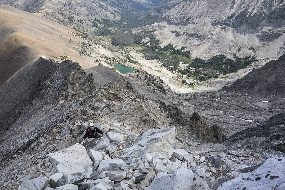
The route to the saddle between Hyndman and Old Hyndman is straight forward. Just keep going up. Jeremy and Jared hiked to the saddle them turned toward the summit. I opted to cut up one of the ribs before actually reaching the saddle. The talus and boulders were a welcome change from my last outing in the Lemhis where steep slopes of sliding scree on The Brow made for an exhausting summit. Maneuvering over boulders sometimes involved some light class 3 climbing which varied the ascent and made it more enjoyable. On the summit I met up with with Jeremy and Jared. After a few photos from the summit we headed down. Five minutes into the descent, I suddenly realized I just closed the loop on the Idaho Twelvers.
 |
| Cobb Peak |
 |
| View from Hyndman Summit |
The following images attempt to Identify some of the surrounding peaks. Any feedback would be appreciated. For some reason I enjoy putting names on the mountains I see. I think identifying them is the first step in learning more about them.
 |
| Looking North |
 |
| Looking South |
I am reminded of an experience I had after climbing The Brow in the Lemhis. I ended up back at my car early in the afternoon and decided to drive to the west side of the range to learn more about the range from Saddle Mountain to Nicholson Peak. I was drawn to a particular mountain that has a distinctive dome summit. I flagged down a local rancher who lives a bit south of the mountain. the beautiful dome dominates his view of the range from his home. I asked him if he knew the name of the mountain. He shrugged and said he had no idea. I was a bit surprised. How could anyone live near such a great mountain and never be tempted to at least give it a local name? I had driven by this mountain several times and always admired its curved line. I had personally given it the name Monticello Mountain after Jefferson's Monticello. I remembered I had the Lopez bible with me and a topo map of the area. Consulting the two sources, I concluded the unofficial name of the mountain was Buckhorn Peak. I was disappointed. Buckhorn Peak! That beautiful curved dome was know as Buckhorn Peak!
Next, I drove towards the mountains heading for North Creek. Up the canyon was a pyramid shaped peak that I was anxious to identify. Near the mouth of the canyon is a hodgepodge house. An old man, Dave, was out watering in the front yard. He was stocky with a big belly that shot out over his tight belt. His face was like dark tanned leather. His chin was covered in rough grey stubble. He wore one of those brightly colored magenta and teal cowboy shirts. When I stopped the car and got out, his friendly Australian Shepard greeted me. I introduced myself and struck up a conversation about the surrounding mountains. When asked about the names of the nearby peaks, he replied, "I've been all over these mountains. I don't give a fuck about what they are called." There I had it. What I was learning that day was I was just plain downright strange to even give some thought to such abstract notions. A rose is a rose. Yet, in my ramblings, I am still motivated to seek out the names of beautiful and striking mountains, as inconsequential as it may be.
Within thirty minutes of coming off Hyndman, the skies darkened and thunder boomed. I kept looking over at Cobb. That was my next destination. I would make the east ridge from the basin below me and, if need be, bivy on the summit or lower slopes. That was the plan. I had already picked out my line of approach as I rounded the south face on the way up. As the skies continued to darken, the east ridge looked more daunting. Thunder crashed all around. did I really want to ascend that ridge in a thunder storm? The debate continued all the way down the mountain. I thought of the tent in my pack and the bivy bag in the car. If I started up Cobb, there would be no place to pitch a tent and no shelter from a storm. I reluctantly begin to let go of an ascent on Cobb.
My thoughts now turned to the next basin to the southeast, Big Basin. It would be from this basin that I would climb Old Hyndman. I kept looking for a trail that would veer off to my left as I passed the southern slopes of Cobb. Found no trail. Getting to the basin would now involve a long hike into thick forests with no trail. Also, I knew I must cross Hyndman Creek at least once to get into the basin. The creek was a wide torrent of crashing white water. The prospect of finding a safe way across looked daunting. The weather continued to get worse. First, there was some light hail, then some light rain. The skies were ominous and thunder continued to bounce around the mountains. I was tired. Catching a movie in Hailey began to look more inviting than a trek into Big Basin. I think my fight or flight instincts were kicking in. Flight was winning. With some relief I let go of Old Hyndman.
Finally, nearing the trailhead, I came across my last obstacle of the afternoon, the North Fork Hyndman Creek crossing. There must have been a flash flood somewhere above the north fork drainage for the creek was much higher than it was in the morning. The torrent of white water was now chocolate brown. The deafening sound of rushing water was now joined by the crashing sound of large boulders being thrown violently down the deluge. I must admit, it was a bit terrifying even standing safely on the bank. I immediately wondered if the bridge was still there.
 |
| North Fork Hyndman Creek, The Afternoon of June 9th, 2015 |
To my joy it was still in place although a support had been ripped apart. I scurried across and watched in amazement the powerful show in front of me. I was happy to be on the side my car was on.
Soon I was on the way to Hailey. Stopped at the Stinker Station just north of Albertsons to bathe and get a Pepsi. Washed my hair, face, and upper body. Then shaved with some Crabtree and Evelyn Sandlalwood Shaving Creme. Refilled my cup with lots of ice and Pepsi...70% diet and 30% real stuff. Felt like a new man. Walked over to the theater. Nothing good was playing. By now the skies had cleared the rest of the evening looked like it would be beautiful, and I felt completely refreshed. Then a crazy idea surfaced. I drove back to the Hyndman Creek Trailhead ready to hike.
I had read about an old cabin, Pioneer Cabin, located somewhere on the ridges west of the north fork trail. Since I was familiar with the trail, it being the one we trudged along in the rain on the 16th, I was emboldened to embark on a adventure to find the cabin and spend the night. I also knew that with the evening light I had some good odds to make a few images. Off I went.
A few miles into the hike, I kept looking for a place to veer to the left and ascend to the upper ridge. The slopes were steep and riddled with cliffs. Finally, I found what looked like a promising route and began the ascent. The climb was like playing a vertical pin ball game with cliffs.
 |
| Slopes to the west of the North Fork |
On the way up, the light was getting great for photos. Unfortunately, there were not many good places to stand and even fewer places to put a tripod. I pulled out my small camera and stood leaning out between two trees, braced with my shoulders, to make some images. The images below were the first images of the day that I liked.
 |
North Fork Hyndman Creek Drainage
Salzburger Spitzl and Handwerk Peak |
 |
| Salzburger Spitzl and Handwerk Peak |
 |
| Salzburger Spitzl and Handwerk Peak |
 |
| Salzburger Spitzl and Handwerk Peak |
Fourteen hundred feet above the north fork trail feet I emerged from the cliffy slopes to see what I could see. It was exactly like I thought it would look like from the topo map. I could see long distances but a cabin was no where in sight. So much for my navigation skills. The upside was the view was incredible and the light was putting on a great show. I made several images.
 |
| The tip of Hyndman Peak, Old Hyndamn, and Cobb |
 |
| The tip of Hyndman Peak |
I walked south debating whether I would spend the night on the ridge. The sun had set and the western sky now illuminated the mountains to the east. Far off in the southeast lightning flashed in the late twilight. I stopped to make more images. The wind had picked up and made it difficult to pull off the long exposures. My light carbon fiber tripod weights a skosh over two pounds and just couldn't handle the wind. Here are a few mediocre results.
 |
| Handwerk, Hyndman, Old Hyndman, and Cobb |
 |
| Hyndman, Old Hyndman, and Cobb |
Still debating whether to pull out my bag, I kept walking south. Finally decided the backlit mountains in the morning light would make poor subjects, I bushwhacked all the way back to the trailhead. Arrived at my car around 11:15 P.M. It was a long day. About 20 miles and about 6,000 vertical feet.
The thoughts of an ice cold Pepsi motivated me to drive back into Hailey. I searched for an all night convenience store and struck out. Disappointed, I drank some creek water from my pack and bedded down in a field north of Albertsons. My mind was already busy conjuring up an adventure for the next day. I have often looked over at the Pioneers from the Lost River Range. The distinctive profile of the Devils Bedstead rises above the Pioneer profile. Tomorrow I would climb it.
In the morning, I drove to Wild Horse Creek and found the Boulder Creek Trail. The day seemed perfect. I was excited for the possibility of summiting Devils Bedstead East.
 |
| Devils Bedstead East from Wild Horse Creek |
The hike in meanders up forested slopes along a well traveled trail. I think the approach is around three miles or so. Not bad. A few miles into the hike, the skies darkened and threatened rain. I kept going thinking it would be much like yesterday's "bark but no bite." I was willing to roll the dice a bit longer. Finally, I reached the boulder fields at the base of the saddle. I climbed the first ridge of boulders. By now there was a heavy feeling in the air foreshadowing imminent rain. Once again, I decided the risk was too high to proceed into the upper ridges. Within ten minutes of turning around lightening flashed and thunder boomed. Rain poured down. I quickly donned a shell and hunkered down for the hike back. Lightening punctuated the darkness all the way down.
Ended the day by eating an enormous chef salad at Pickles in Arco before heading home.
 |
| Devils Bedstead |
Other Resources:
Tom Lopez Website:
Hyndman Peak
For more trip reports of other mountains visit
idahoclimbing.weebly.com